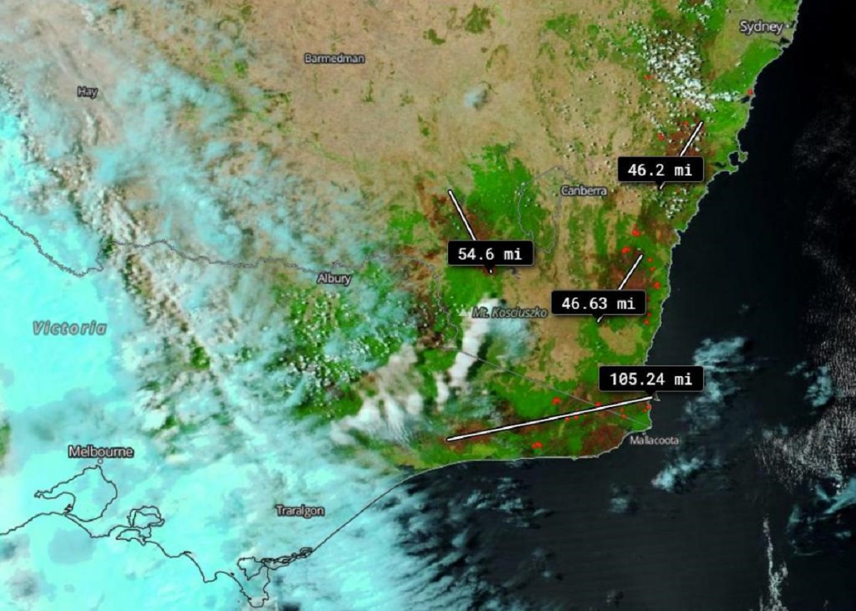
The Australian bushfire has left behind burn scars. The violent and vicious bushfires that raged throughout southeastern Australia have caused massive destruction, not just to mankind, but to wildlife as well. A satellite image captured by NOAA/NASA's Suomi NPP satellite shows the burn scars caused and left by Australian bushfires. This image was captured on Jan. 22, 2020, NASA said, adding the measurement ranged from 46 miles (74 km) all the way up 105 miles (169 km) of scarred land.
Just looking at the image is devastating enough, but the measurement underlines the absolute destruction caused by the bushfires that took hold in 2019 and into 2020.

Colors have been enhanced used reflectance bands on the satellite that provide more vivid colors in order to "see" the differences between the land and the burn scars, the US space agency said. This combination is most useful for distinguishing burn scars from naturally low vegetation or bare soil and enhancing floods.
NASA’s satellite instruments are often the first to detect wildfires burning in remote regions, and the locations of new fires are sent directly to land managers worldwide within hours of the satellite overpass.
Together, NASA instruments detect actively burning fires, track the transport of smoke from fires, provide information for fire management, and map the extent of changes to ecosystems, based on the extent and severity of burn scars.
NASA has a fleet of Earth-observing instruments, many of which contribute to our understanding of fire in the Earth system. Satellites in orbit around the poles provide observations of the entire planet several times per day, whereas satellites in a geostationary orbit provide coarse-resolution imagery of fires, smoke and clouds every five to 15 minutes.
Meanwhile, dust storms, hail and flash floods have battered beleaguered Australian cities in recent days, extreme weather that has diminished the threat from scores of wildfires that continue to blaze across the country’s southeast.
A hail storm in the national capital Canberra on Monday damaged public buildings, businesses, homes and cars, cut power to some suburbs, brought down trees, caused flash flooding and injured two people, emergency services officials said.
The fires have claimed at least 28 lives since September, destroyed more than 2,600 homes and razed more than 10.4 million hectares (25.7 million acres). The area burned is larger than the U.S. state of Indiana.
Also Read | NASA's Hubble Space Telescope spots bright galaxy located 200 million light-years away
Also Read | How world's last remaining dinosaur trees were saved during Australian wildfires