The extremely severe cyclonic storm Fani, which is currently situated at about 370 km southwest of Kolkata, is likely to enter West Bengal with a wind speed of 90-100 kmph gusting to 115 kmph by midnight to Saturday early morning, an official said here on Friday.
Here are some important points about Cyclone Fani approaching West Bengal:
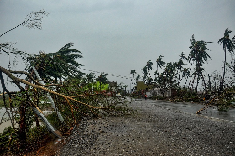
# The storm, which has crossed the Odisha coast near Puri, would enter West Bengal as a severe cyclonic storm and the gale would start from the coastal districts adjacent to neighbouring Odisha.

# The storm would emerge in Gangetic West Bengal as a severe cyclonic storm with wind speed of 90-100 kmph gusting to 115 kmph and the gale will reach maximum velocity around late midnight or early Saturday morning.
# The storm would further weaken into a cyclonic storm by afternoon or evening on Sunday and move to Bangladesh with a wind speed of 60-70 kmph.
# Rainfall between light to moderate and extremely heavy (20 cm) is likely in some places over Kolkata, East and West Midnapore, Jhargaram, North and South 24 Parganas, Howrah and Hooghly districts.
# Heavy to very heavy rain (7-20 cm) is also likely at one or two places over Purulia, Bankura, East and West Burdwan, Burbhum, Murshidabad and Nadia districts.
# The outer ring cloud band has already reached the coastal areas of West Bengal and Kolkata, prompting rainfall. The rain intensity will be gradually increasing. As the cyclone comes closer to Bengal it will have a speed of 80-100 kmph.
# All precautionary measures like flight cancellation at airports, cancellation of trains and water transport services have been taken.
# In the Shalimar Railway yard, the trains have been tied with heavy chains as a precautionary measure.
# In order to tackle any emergency situation, six teams of the National Disaster Response Force (NDRF), have been deployed in Jhargram district's Sankrail, West Medinipur's Narayangarh Block, in Ramnagar of East Medinipur district, Kakdwip in South 24 Parganas, Dhamakhali and Hasnabad in North 24 Parganas district.
# The state government and the Kolkata Municipal Corporation are shifting people living in low lying areas to safer places. The Kolkata Municipal Corporation also has formed a team comprising the state Police and Disaster Management Authority officials to monitor the measures being initiated.
# A toll-free helpline number 1070 is also being circulated for assistance.
Watch Video:
Also Read: Finding 'Fani': In Bhubaneswar, a newborn named after cyclonic storm
Also Read: Cyclone Fani, a Category 5 hurricane, makes landfall: A million evacuated | Highlights
(With IANS Inputs)