
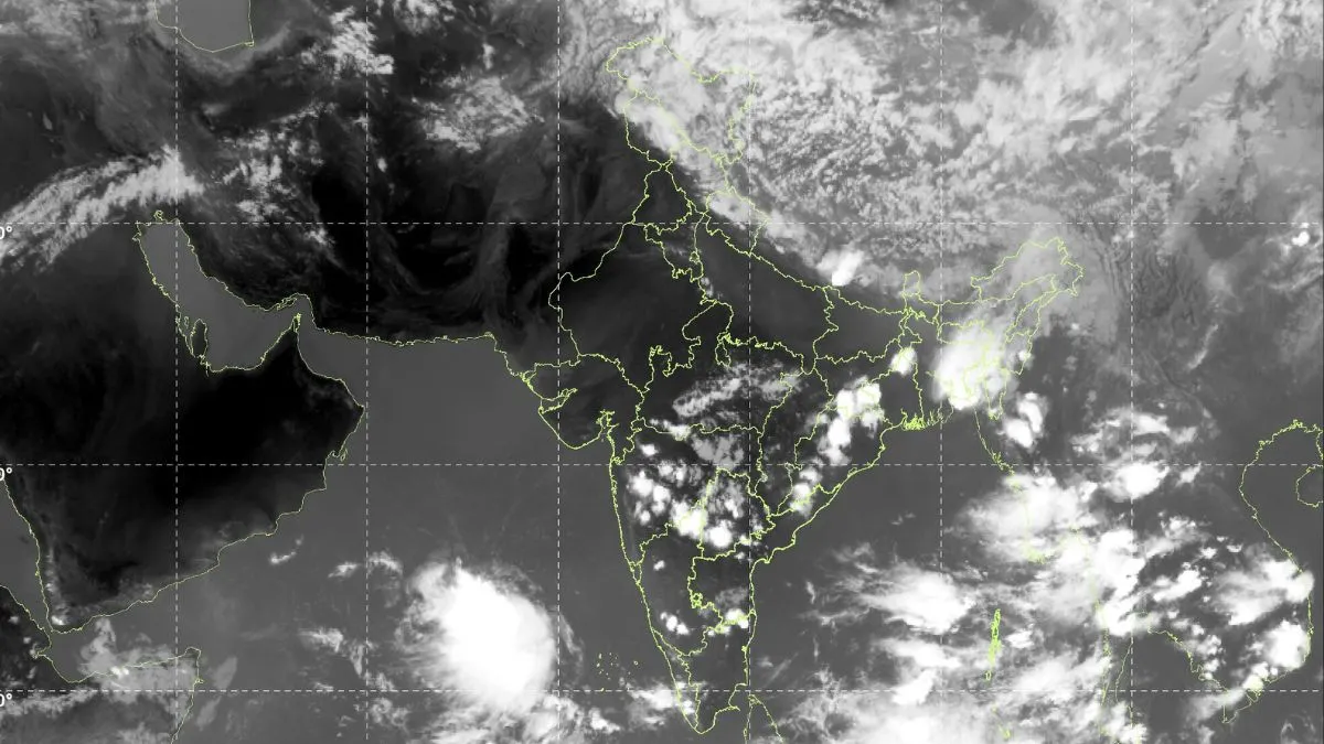
Storm clouds gather over the Himalayas while the southwest monsoon rapidly advances towards Kerala. Satellite images released by the India Meteorological Department (IMD) show massive cloud formations stretching across northern and southern parts of the country, signalling intense weather activity in the coming days. The IMD has issued yellow alerts for rain, thunderstorms and gusty winds across several Himalayan states, while also warning of heavy rainfall in Kerala as monsoon conditions strengthen earlier than usual.
A powerful western disturbance moving across North India has led to unstable weather conditions in the Himalayan region. Latest satellite imagery from INSAT-3DS shows a huge spiral-shaped cloud system spread across Jammu and Kashmir, Himachal Pradesh and Uttarakhand.
Meteorologists say the dense white cloud bands seen over the western Himalayas are signs of towering thunderclouds capable of producing heavy rain, lightning, strong winds and even isolated hailstorms. The weather system is forming due to the interaction between the western disturbance and extremely hot pre-monsoon air over northern India, creating conditions for sudden and intense storms.
Kerala braces for early monsoon arrival
While northern India deals with storm activity, another major weather development is unfolding over southern India and the Arabian Sea. Large clusters of deep rain-bearing clouds have formed near Kerala and Lakshadweep, indicating strengthening monsoon activity over the region.
According to the IMD, the southwest monsoon is likely to reach Kerala around May 26, nearly a week earlier than the normal onset date of June 1. If this happens, it would mark one of the earliest monsoon arrivals in recent years.
Satellite images show thick cloud bands southwest of Kerala and vigorous thunderstorm activity over the southeast Arabian Sea, both considered important indicators of monsoon onset.
Heavy rainfall warning issued
The IMD has also warned of isolated heavy to very heavy rainfall in parts of Kerala between May 28 and June 3 as the monsoon current gains strength. Weather experts say such intense rainfall episodes are common during the early burst phase of the monsoon, when large amounts of moisture suddenly move inland from the Arabian Sea.
Authorities are closely monitoring the situation as heavy rain during monsoon onset can lead to waterlogging, flash floods and disruptions in vulnerable areas. Even as rain systems strengthen over parts of the country, several regions in northwest and central India continue to remain under severe heatwave conditions.
Meteorologists say the clash between scorching dry air over central India and incoming moisture-laden systems from the Arabian Sea is helping fuel violent thunderstorm activity across northern regions. The satellite imagery captures this transition clearly with dry, heatwave-hit regions spread across central India while giant storm systems churn simultaneously over the Himalayas and southern seas.