Google today announced three more features to Google Maps in India, to make public transport journeys more efficient and seamless: Bus travel times from live traffic in 10 of the largest cities in India, live train status for Indian Railways trains, and mixed-mode commute suggestions that now combine auto-rickshaw and public transport.
"From a college student hopping onto a bus, to a family on vacation boarding a train journey to the serene beaches of Goa, public transport is the lifeblood of millions of Indians. And Google Maps is being used by over a billion travelers to navigate and explore their world, wherever they are. Beyond providing the ability to simply navigate between places, we have focused on building India-first features for Google Maps, to deliver a more relevant, accurate, and reliable experience," Google wrote in its blog.
Google Maps users in 10 of the largest cities in India will be able to see bus travel times from live traffic, get live train status for Indian Railways, and get mixed-mode commute suggestions that now combine auto-rickshaw and public transport.
The 10 Indian cities that will benefit from Google Maps new feature are - Delhi, Bangalore, Mumbai, Hyderabad, Pune, Lucknow, Chennai, Mysore, Coimbatore, and Surat.
Here's how it works:
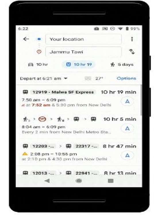
- To see this feature, simply enter your starting location and destination, then tap the transit tab. The results for bus travel times from live traffic will be shown.
- Similarly, for train running status, enter the starting point, then the destination and tap transit tab. You will get the results showing the scheduled timings and delayed timings.
- This feature uses Google's live traffic data and public bus schedules to calculate delays and provide accurate travel times.
- Google Maps also keeps a track of the train and help users know the real-time running status. Google Maps will help you know when your train will arrive by indicating the real-time status.
- The public transport tab on Google Maps for Android suggests users about which public transport is a good option. It also indicates how much time it will take, and which metro station they should take an auto-rickshaw to/from.
- Rickshaw meter estimate and departure times for their transit connection are also visible.
- The new features are available on Android, iOS and mobile web.
Also Read: Google Maps will now bring you Live Train status and bus info

Also Read: Google Maps soon to show crowdsourced menu pictures of most popular dishes across restaurants