NASA's National Oceanic and Atmospheric Administration satellite Suomi NPP has captured some jaw-dropping images of dangerous Typhoon Meranti as it hit the Philippines island of Itbayat in the Luzon Strait yesterday.
Itbayat is the largest island in the province of Batanes, northern Philippines.
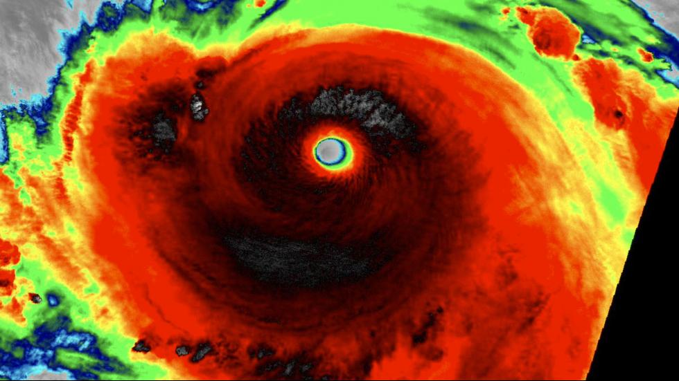
As per NASA report, on September 14, the Visible Infrared Imaging Radiometer Suite (VIIRS) instrument aboard the Suomi NPP captured an infrared image of Typhoon Meranti as it hit the island of Itbayat.

The dark red colours in the images captured by the satellite indicate the colder (and higher) cloud tops as cold as 70 degrees Fahrenheit.
Suomi NPP satellite also captured a night-time image when Super Typhoon Meranti as it hit the island of Itbayat.
VIIRS collects visible and infrared imagery and global observations of land, atmosphere, cryosphere and oceans, said NASA.
Meranti was a Category 5 typhoon, the strongest classification awarded by Tropical Storm Risk storm tracker, before it made landfall on the mainland and has since been downgraded to Category 2.
Typhoons are common at this time of year, picking up strength as they cross the warm waters of the Pacific and bringing fierce winds and rain when they hit land.
Another up-close view of Meranti's eye on Tuesday.
This final look a Meranti is an animation of visible satellite imagery from early Tuesday.