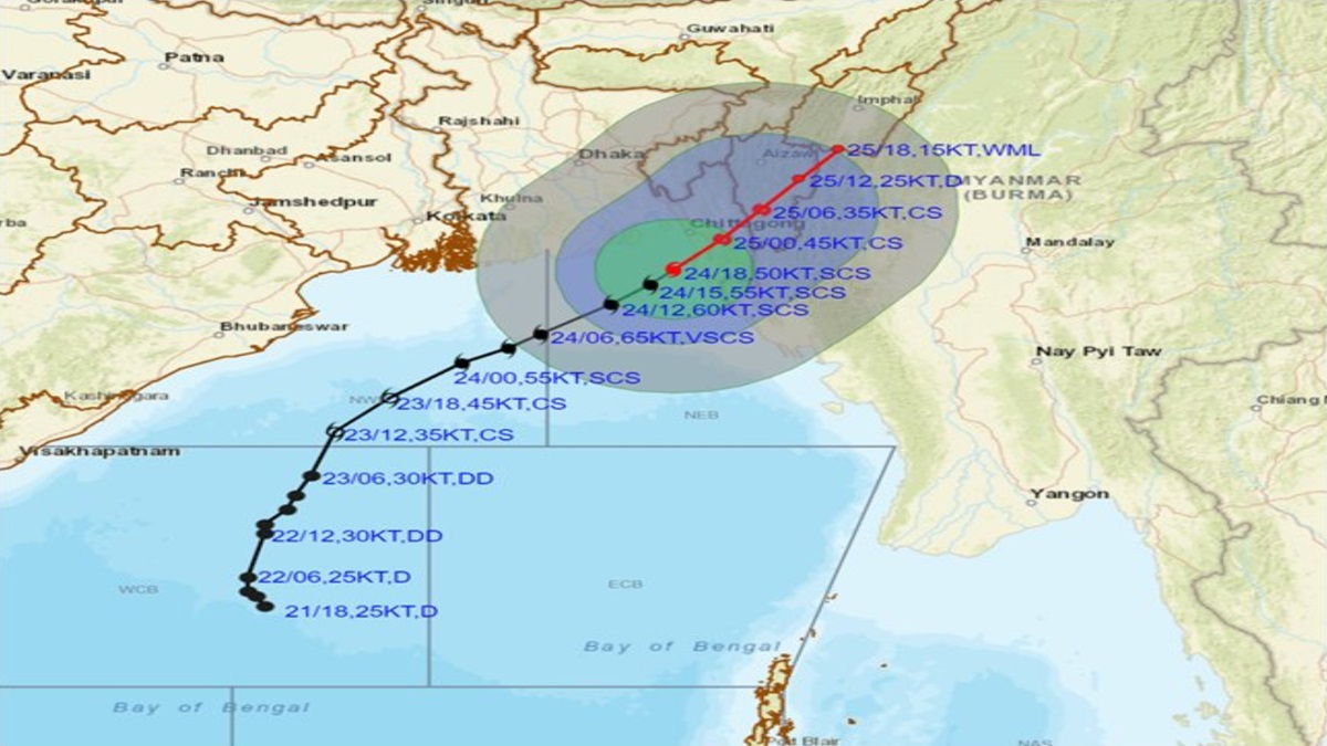
Hamoon and Tej updates: The landfall process of Cyclone Hamoon has commenced and it weakened into a cyclonic storm across the Bangladesh coast area to the south of Chittagong with wind speed of 80 to 90 kmph gusting to 100 kmph, said India Meteorological Department in a post on X on Wednesday.
"Landfall process has commenced. To weakened into a cyclonic storm and cross Bangladesh coast to the south of Chittagong within a few hours with wind speed of 80 to 90 kmph gusting to 100 kmph," IMD posted on X.
On the other side, another Severe Cyclonic Storm (SCS) Tej reached over coastal Yemen and weakened into Cyclonic Storm (CS) at 1130 IST on Tuesday.
Two cyclones - Hamoon and Tej - brewing over the Bay of Bengal and Arabian Sea, triggered rains in several parts of Odisha and West Bengal.
Earlier, the IMD on Tuesday predicted that a few Indian states are set to experience some storm activities this week.
What is the status of cyclone 'Tej'?
According to the weather department, Tej was spotted over coastal Yemen and it weakened into a Cyclonic Storm from Severe Cyclonic Storm on Tuesday night. Tej will move further west-northwestwards and weaken into a depression during the next few hours.
"It almost crossed Yemen coast close to south of Al-Ghaidah within a few hours as a Cyclonic Storm with wind speed of 125-135 kmph gusting to 150 kmph," added the IMD.
Check here your city's weather forecast for today
Rain alert in these states
According to the weather department, moderate rainfall with isolated heavy rains (64.5 mm-115.5 mm) in the northeastern states of Nagaland, Manipur, Mizoram, Tripura, south Assam, and Meghalaya until October 26. The Odisha government has asked all the district collectors to remain prepared for any eventuality, and directed the administration to evacuate people from low-lying areas in the event of heavy rain.
"The system (cyclone) will move over the sea around 200 km from Odisha coast," weather scientist US Dash said, adding that under its influence, light to moderate rainfall is likely at a few places in coastal Odisha and at many places over the next two days.
IMD Director General Mrutyunjay Mohapatra said the wind speed over the Bay of Bengal will gradually increase to 80-90 kmph gusting to 100 kmph.
(With PTI inputs)
Also read: Depression over Bay of Bengal triggers rains in parts of Odisha, West Bengal
