15 pc of Mussoorie landslide prone; Bhataghat, Kempty fall among most prone. Details here
A study by the scientists at the Wadia Institute of Himalayan Geology (WIHG) has found that 15 per cent of Mussoorie hill station in Uttarakhand and its surrounding area is highly susceptible to landslides, a statement said on Monday.
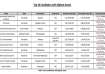
It found that the dominant part of the area falling under the very high and high landslide susceptible zone lies in the settlement area -- Bhataghat, George Everest, Kempty fall, Khattapani, Library road, Galogidhar, and Hathipaon -- and is covered by highly fractured Krol limestone exhibiting slope more than 60 degrees.
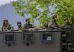
Like most hill townships, Mussoorie, the popular hill station, has witnessed several landslides, probably resulting from an increased spate of developmental activities, as per the study.
“The increased disaster hazard has led scientists to map the landslide susceptibility of Mussoorie and surrounding areas, showing that 15 percent of the region is highly susceptible to landslides,” the statement said.
The scientists from the WIHG, an institute under the Department of Science and Technology, Union Ministry of Science and technology, carried out the study in the Mussoorie township and its surroundings covering 84 square km in the Lesser Himalaya, it said.
They found that the dominant part of the area falling under very high and high landslide susceptible zone lies in the settlement area --- Bhataghat, George Everest, Kempty fall, Khattapani, Library road, Galogidhar, and Hathipaon --- and is covered by highly fractured Krol limestone exhibiting slope more than 60 degrees, the statement said.
The Landslide Susceptibility Mapping (LSM) published in the Journal of Earth System Science also showed that about 29 per cent of the area falls in the moderate landslide susceptible zone and 56 per cent in low to very low landslide susceptible zone, it said.
The researchers from the WIHG carried out the study using the bivariate statistical Yule Coefficient (YC) method utilising Geographic Information System (GIS) and high-resolution satellite imageries.
According to the study, various possible causative factors of landslides in the study area include lithology, landuse-landcover (LULC), slope, aspect, curvature, elevation, road-cut drainage, and lineament.
The study could help initiate a large-scale landslide hazard, risk, and vulnerability assessment (HRVA) of the hilly townships in different parts of India, the statement added.